Badger Peak
Length of: Hike 8.5 Miles
Difficulty: Moderate
Description of Hike:
This hike starts on Forest Road 26 at Elk Pass. This is trail #1 or Boundary Trail,
called that because it runs along the boundary of the St Helens ranger district
and the Randall ranger district. There are very distinct differences in the way
these two districts manage their areas. The first couple of miles are through a
stand of timber along a wide ridge. There is no real view along the trail here.
The trail climbs and descends a couple of time, climbing a couple of hundred feet
in the first mile and becoming more moderate over the next mile. After a couple
of miles the trail intersects with trail #292 that drops off to the north side of
the ridge. It crosses a meadow and ends at Forest Road 28. This is a good area for
picking huckleberries in the late summer. The trail is ash covered and very dusty
in the summer. The trail is also open to dirt bikes so it is rutted deeply in many
places. One of the major differences between Randall ranger district and St Helens
ranger district is that Randall seems to allow a lot of motorized trail use.
After the intersection the trail continues off to the south side of the ridge. Climbing
three hundred feet or so over the next 1/2 mile, then crossing behind a small peak,
the hill side slopes away from the trail at a very steep pitch, covered in brush
and timber. Over the next 1/2 mile or so, the trail moves back onto the ridge top.
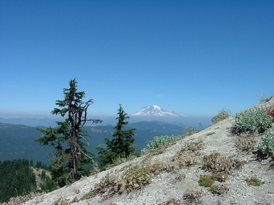
The ridge here is very narrow and the view to the north presents a couple of large
rocky buttes.
The trail climbs a bit more and finally flattens out as it approaches Badger Lake
in the last mile. The area has seen use by the dirt bikes, which is evident on the
small ridge to the south of the trail, as it approaches the lake. Hiking on, the
lake is just a short distance off the trail. When I was there in the late summer,
the size of the lake was reduced leaving some nice meadows. On the far side of the
lake is a slide that looks like it runs to the top of Badger Peak
From here it is 3/4 of a mile and over 500 feet to the top of Badger Peak. Backtrack
from the lake to trail #257 which is just a few hundred feet back and follow it
to the spur trail #257A which takes you to the top of the peak. It is a steep climb
but not too radical until you get almost to the top. Then it crosses the slide that
you can see across the lake at the bottom. You can see the lake at the bottom of
the slide and it is a little sketchy crossing it. The trail rounds the peak and
becomes very narrow and steep for the last few feet. At any rate, I had to coax
my 13 year old son to the top because it was so steep and breaks out of the timber
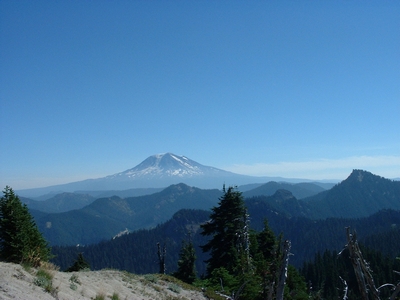
at the last little bit which exposes you to the steepness. But it is worth it. One
spectacular 360 deg. view. This is an old fire watch station and the concrete and
steel still remain.