Horse Tail Falls and Oneonta Gorge
Length of Hike: 2.5 Miles
Difficulty: Easy to Moderate
Suggested Skill Level: Novice
Trailhead longitude and latitude: 45 35 23N, 122 04 08W
Google Trail Head Location Google Trail Marker
 Google Directions From Portland
Description of Hike:
Horse tail falls to Oneonta Gorge.
An easy day hike with exceptional sights and views. The hike can be accessed from ether the trail head at Horse Tail Falls trail#438 or the trail head for Oneonta trail #424. Trail #424 and #438 both share their line with trail #400 the Columbia Gorge trail.
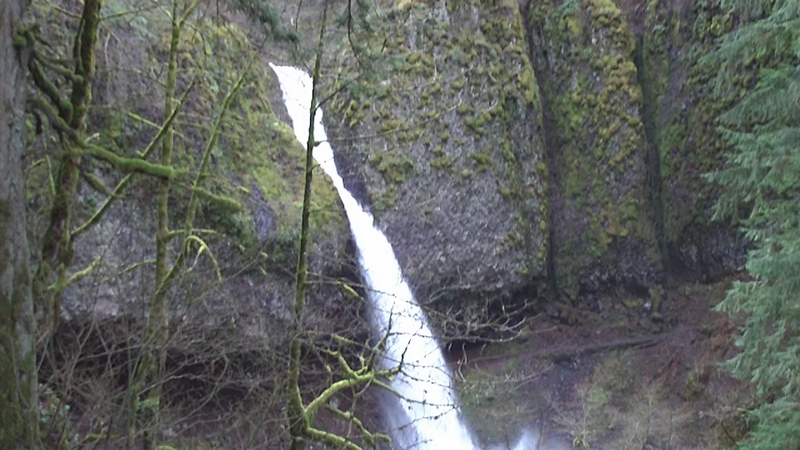
My visit, on a mild day in late winter, found Horse Tail falls making a deafening roar as the water fell from the cliff above and pounded the rock face 50 or 60 feet above me. Creating a fine mist that spread out over the area as the water continued to plummet to the basin below. The heavy mist dampened both me and the lens of my camera as I approached to take some pictures.
The large pool formed by the falls is surrounded by a rock wall that was built back in the early 20th century. The stone work is a credit to the masons of that era. The moss that grows on these stone walls highlights each stone union and creates a florescent yellow green pattern of perpendicular lines.
Starting at Horse Tail Falls the path climbs quickly at a moderate grade. The trail makes five switchbacks on the way up until it levels off at around 350 feet after making a climb of just over 300 feet based on my GPS.
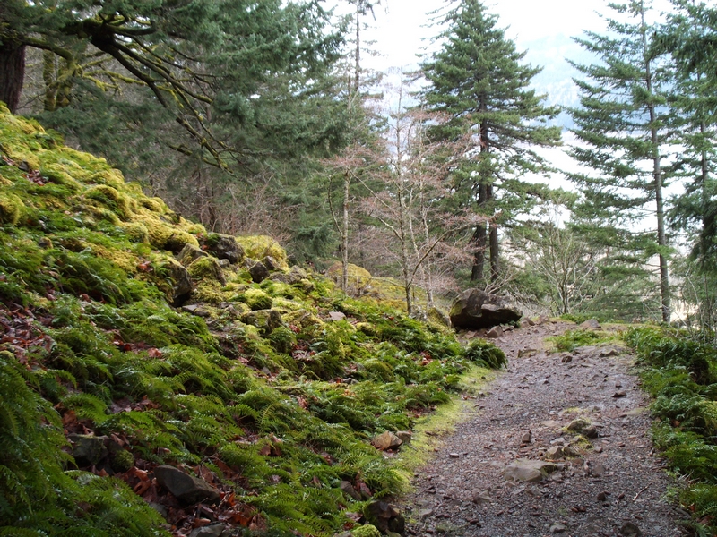
The tread is very rocky, well worn angular stones in abundance, packed into the trails surface. The path is broad and the hillside is covered with a blanket of medium sized delicate looking ferns.
Every switchback seems to have a stone wall above and below to support the trail. The stones in the wall blanketed with thick green moss.
The trail moves higher and further away from the falls the ferns in the undergrowth start to thin out a little. A couple of small rock slides encroach on the edge of the trail and dump a few lose stones across it.
On the third switchback the Gorge trail #400 from the east merges with the trail, a much thinner track and most likely a more technical trail.
By the time the trail makes the 4th switchback the sound of the falls is starting to fade.
After the 5th and final switchback on the ascent, the incline becomes less intense about 50 feet from the trail the face of a cliff extends upward for another couple of hundred feet. This rock wall broken to form a terrace about half way up with trees tenaciously holding to the thin soil layer.
There is so much moisture on the terrace above that in some places the rock face is covered with a thin vale of water that drips continuously.
The hillside slopes sharply away from the trail and over a cliff, the parking lot and road side viewing area clearly visible below. It has become almost level at this point. The makeup of the trail has not changed it is still rough.
A panoramic view of the Columbia River and the Cascades is laid out in front of you.
It is very impressive along here with the large fir trees growing along the edge of the cliff.
This is not a place to let small children or pets run un-attended. The cliff is right next to the trail and at times the spacial effect is almost overwhelming.
The trail turns to head away from the cliff. The stream that flows over the cliff and forms Horse Tail Falls is visible below the trail but the roar of Pony Tail Falls overpowers everything else as your eyes are drawn to the site.
The water spills over a massive black and gray rock formation accented with tufts of bright green moss and a grove that has worn in the face from eons of water running through it.
A large cavernous area has formed below the rock formation which allows the passage of the trail behind the falls. This allows a spectacular 360? view of the torrent of water falling through the gouge in the cliff above.
The roaring noise is deafening as it surrounds you, bouncing off the faceted faces of the cavern. The column of water that makes up the stream plunging into the bolder laden pool below, throwing up a mist that soaks the area and makes the hard packed trail shimmer.
Standing behind the falls the sharply formed V of the valley containing this stream is laid out with the Columbia River in the distance.
As the trail exits the cavern it becomes narrower with a short steep section. Above the trail stands an extension of the lava formation segmented into columnar sections, causing the valley to take on a bowl like shape. The opposing side of which is just very steep hill side covered in timber, with ferns growing below.
The trail moves back out to the travel on top of the cliff, the noise from the freeway and trains becoming the predominate sound. There are large conifer all along this stretch, growing up and down the steep hillside with a carpet of smaller ferns below them.
The trail is a little rougher along here, there is a small outreach extending out over the cliff, a weak knee spot to make an observation. I, myself, could not walk out there but the surface is well packed and shows evidence of many people occupying that spot.
There excellent points of observation on the bluff just as the trail approaches Oneonta gorge with the Columbia River Highway below. From here the gorge stretches out both east and west. To the East is Beacon Rock standing on the edge of The Columbia River. The banks of the Columbia covered primarily with deciduous trees.
The trail going into Oneonta Gorge is wide and descends slightly.
There is a small water fall dropping over the edge of the rock bluff high above the east side of the trail. The water has pushed some rock out onto the edge of the trail and spreads into a wide flow across the trail.
Around the next bend a large tree has fallen off the cliff and now stands upside down. The tree leans across the trail and rests against the face of the cliff, the roots exposed and washed clean by water that is running over the edge of the cliff and spreading out across the rock, filtering through the moss and ferns. The water from this falls continues flowing across the polished stones that make up the trail along here.
Approaching the edge of the Oneonta Gorge, the trail starts a series of six switchbacks down to a steel foot bridge that spans the creek some 20 feet or so above it.
Each switchback supported by old stone work. At the second switchback there is a view of the Gorge, a very narrow crack through the lava flow. With the creek running, frothing white water patches broken up by placid stretches where I imagine the water is being held back by the boulders and trees that have been swallowed up in this ravine.
The trail through these switchbacks is steep and in a couple of spots the rock is covered with a thin coating of water, requiring caution as you descend.
From the fifth switchback there are numerous trees visible in the gorge that have fallen from higher up the hill side and lay propped up with root wads, covered in dirt, still attached.
Oneonta creek dumps over a drop of about 20 feet just as it approaches the bridge, the basin below the bridge is a jumble of trees that have washed down from above. The broken trees washed down steam supporting a small dam which causes the water below the bridge to form into a placid pool.
From the bridge the trail ascend sharply down stream. Supported on the stream side by large fir trees, it is very rugged along here. A couple of places along the climb there are large fir trees that can be used as a secure perch from which to try and look into the gorge.
Only a couple of switchbacks and the trail junction for Oneonta trail #424 intersects here with the gorge trail #400. Trail #424 will take the traveler to Triple Falls after about a mile and a half climb.
The main trail continues downstream with a mile ascent for a quarter mile, descends a little bit to an unmarked junction. This junction leads to another overlook.
The last part of the trail is pretty much just a walk. The trail descends at a moderate to easy descent with one switchback. It crosses a washed out spot where there has been some water damage. The most interesting part of section of the trail was that as the trail came closer and closer to the Columbia Gorge, there was this strange noise. It turn out to be frogs, there must be thousands in the wet lands on the other side of the old highway. The noise they make is almost defining.