Indian Pits at Silver Star Mountain
Length of Hike7
Difficulty: Difficult
Description of Hike:
The trail head for this hike is located at a spot called Grouse Vista Overlook. The trail starts on the east side of the road. This trail is about a three mile ascent with a couple of grades that are over 20%. As the trail leaves the road, there is a branch to the north that eventually takes the hiker to the same place, but it is about a mile longer. I meet another hiker at the top of the trail, that had just come up that way, and he told me the last mile of the hike was a very steep ascent. The trail starts right out with the a steep climb that goes for about 3/4 mile. The path is littered with large lose stone. One has to pick and chose their footing well. The rocks range from fist size boulders to bowling ball sized rocks. There is a lot of quarts in the rock and most of it is flat and shale like, making them easy to slip on. I think a bike or even a horse would have a hard time on this trail.
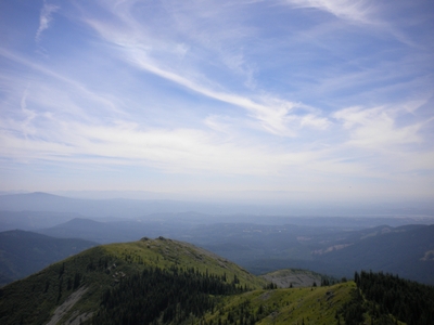
Just as the ascent starts to subside, the forest cover gives way, and the view has an alpine feel. The terrain all around is very steep, with two large rock outcroppings ahead. The trail here is a much more moderate 10 to 12% grade. Off on the left across a deep valley, is another very large outcropping that I think is Sturgeon Rock. As the trail continues past the first outcropping, which is more of a peak in comparison to the next up ahead, the trail descends a little as a road branches off of the trail to the southeast. In fact the trail is an old road, when you hike this it is very hard to believe that vehicles traveled along here, as narrow and steep as it is. The trail again starts to climb as it swings around the second outcropping. The outcropping itself jutting upward, very uninviting. There does not seem to be any trails going up there and the slope is extreme, not one I would venture up. As the second rock formation starts to fall behind, the trail leads back into the woods. The grade again becomes very steep, as it increases beyond 20%.
Another road/trail joins this one, coming up from the south. Then after another 1/4 mile, the trail turns north and the grade subsides, with a slight incline turning to a slight decline as it extends the last 1/4 mile to a junction of four trails.
At the trail junction, coming up from the West is the trail that diverged from this one at the start. Coming from the North is the trail to the top of Silver Star, and on the East is the one to the Indian pits. The only one that is not an old road is the one to the Indian pits. It leads off to the south, along a step ridge face for a short while then breaking out on to the top of a ridge. The trail it self is narrow, but very easy to walk compared to the road that led up to this point. The terrain is covered with low huckleberry brush. As the trail descends along the ridge, the view is again spectacular. Off to the west you can now see all of Vancouver and further out to the coast range. It feels as if you could see the ocean from here. The elevation of the ridge is around 3800 feet. Off to the east, there is another ridge running south parallel to this one. A trail can be seen running across the face from north to south and from here it looks as though is would be a bit scary to cross. The trail traverses an open face that looks like it is covered with scree. It is a good 1/2 mile and the slope that it crosses must be at least an 80% grade. Just as the ridge this trail follows, drops off into the same valley with a similar grade. The ground runs down away from the trail gaining pitch the further out it goes, until it drops out of site, about 100 feet away.
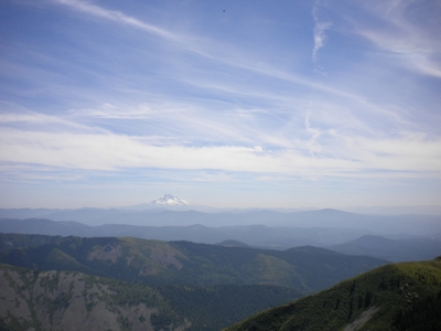
Following the trail, the descent increases at about a 1/2 mile, and then levels out into a small alpine meadow. The meadow has seen campers here, with the campfire ring in an area that looks as though it has seen many tents. The trail swings to the east of the meadow and then looks to almost disappear into the huckleberry brush. Pushing through the brush the trail starts an ascent. The brush is thick and there are small conifers along the trail with limbs that have to be pushed out of the way of the hiker. In a short while the brush gives way to the open area again and before you is the Indian pits area. I only observed one area that looked like it might have been a pit. The whole area is large lava rocks, which are probably a foot across on the average. The trail moves to the eastern side of the ridge passing the one area that looks like it may have been one of these pits, the rocks here were showing evidence of a small depression. Moving further along the ridge the trail ends at an outcropping. A beautiful area to eat lunch or enjoy a snack. The view is memorable and worth every minute of the hike to get here. To the north you can see Mt St. Helens, with Mt Rainer in the background. Then off to the Northeast is Mt Adams. The view to the Southwest holds Mt Hood, and far off in the distant south Mt Jefferson can be seen. The outcropping here is easily mounted, with the top being flat. The terrain to the south of the outcropping drops off at an extreme grade. Standing on the top of this rock makes one weak in the knees.
I say again a spectacular view worth the arduous climb of more then 1600 feet and almost 4 miles one way on a trail mostly covered with lose hard scrabble rock.