June Lake
Length of Hike: aprox 5 miles
Difficulty: easy to moderate
Description of Hike:
June Lake Trail, and two loop hikes back to the trail
head. Both hikes start at the June Lake trail head. The parking area is large enough
to accommodate about 15 to 20 vehicles, and it may get that many on a nice day.
The area surrounding the parking area to the east and south is fairly clear of under
brush, making most any where a nice place to set up camp, or a picnic.
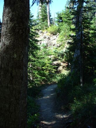
The trail heads north from the parking area along
side the stream that comes from June Lake. It quickly leaves the stream though and
heads off to the north and east. Making a large arch for about ˝ mile, then returning
to a location above the stream. There are some limited views of the valley that
contains the creek from here. The trail continues parallel above the stream, for
another ˝ mile. As it starts to approach the lake, it becomes much steeper though
still very accessible. Just before arriving at the lake, the trail crosses a small
bridge. The lake is not a large lake, and appears to be rather shallow, at least
at the accessible end. The north and east sides of the lake are cliffs and very
steep terrain. It is feed by a small water fall almost directly across from where
the trail ends at the lake. Uniquely, a tree has fallen from the north face of the
cliff, and landed as if some one had planted it upside down. The root structure
sticking high in the air.
When I say the trail ends here, that is because it appears to. There are two trails
leading to the north and west from this location. Both trails are a little hard
to find.
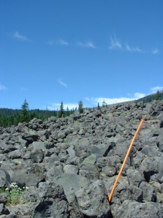
The first return route is across the lava field that
lies to west of the lake. The trail is unmarked and the hiker has to pick his way
across it. The trail heads to the northwest, and although it is not very far the
going is slow. When I was there, there were orange markers stuck in the lava field.
These may or may not still be there, but if the hiker just keeps going across to
the northwest they will get to the other side. The trail on the other side is not
well marked ether, but there are two ridges running away to the northwest and the
trail is to the south of the southern most ridge. We climbed over one small ridge,
and up another to where the tree line was, and found the trail following the ridge.
Another Ľ mile and there is a trail junction. The trail that this one meets is an
old road, and in the winter a cross country ski trail. Although I have not done
it, the map shows the trail can be followed on up the hill to a point where it meets
another trail that can be followed back to June Lake.
By going down hill to the south the trail will lead
back to the road from which the trail head is accessed. The trek is about 2 to 2
˝ miles. At the bottom there is a gravel quarry. From there the road is only a few
hundred feet away. The road to the trail head is about a ˝ mile east down this road.
An alternate is to follow the cross country ski tail that parallels the road back
to the trail head road.
The second return route is not well marked, it is
about ˝ way between the lake and the lava field. The trail goes north behind June
Lake. It starts out as a steep climb toward the lava field, the switch backs toward
the lake, always climbing. As it crosses back behind the lake there are some nice
limited views through the trees of the lake. I made this hike with my son, and we
planed on doing a little bush whacking across to another trail for our return trip.
The trail intersects another trail not far behind the lake, trail 216. Our plane
was to go to the east from here, the trail winds through some lava fields, but it
is very well developed and easy to maneuver. It crosses above a deep ravine then
starts to parallel the ravine, on the south side, in the timber. This is where we
had decided to cut across to another trail. The map showed a trail that ran parallel
to this one, but about a ˝ mile to the southwest.
We took a compass heading, and started off in that
direction. We also had our beagle with us, and she lead the way, on a short leash.
We encountered a steep hill right away, but after climbing over that we started
through the woods. The terrain and vegetation was such that our path kept steering
more to the south than our first reckoning had indicated we should go. We continued
on through a thick huckleberry patch, which was very easy to negotiate with the
beagle. Since she is low to the ground it was a natural for her to find an easy
path through. I just had to keep her headed in the right direction. After a while
it was apparent we were heading too much to the south, so to correct our course
we headed up hill almost due east. In just a few minutes we hit the trail.
Looking up the trail, it was obvious we had been
paralleling it for some time. The trail like a lot of the trails up there is an
old road. We hiked down it for about ˝ to ľ miles and came to some type of transmission
tower. From there the road was in very good repair. We walked another ľ or so miles
and came to an intersection.
To the west was another older road. There were no
sign posts, and after checking the map, it appeared to be the road we wanted to
descend back to the highway on. Our plan was to follow this road/ski trail back
to the highway and then walk another ˝ mile or so back to the trailhead road. We
traveled a ˝ mile or so down the road, and looking over the map, decided to cut
across the ridge to the June Lake trail. I could see a peak straight to the west
of us, and if we crossed just behind the peak, the map terrain looked as though
we could negotiate it.
The spot we picked to leave the road was a spring area, very wet, although we never
got our feet wet, it was not the best place to leave the road. The other side of
the spring had a small muddy embankment that we climbed with the help of the overhanging
brush. A little further through the brush heading west and we came across an old
logging road.
Seeing this road, the thought crossed my mind that
we could have probably picked it up from the road we were traveling on and saved
our selves the work of crossing the spring area. The road was heading in the direction
we were heading so we followed it up through a swale between a peak and the ridge
that runs parallel to the June Lake trail. The road ran downhill another hundred
feet or so, then ended at a drop off. The view from here was exceptional.
I suggested we make our way down following an animal
trail that headed a little to the northwest, but my son who is very cautious, suggested
we go back up to the ridge and see if we couldn’t make our way down through the
trees. The slope in front of us was a little intimidating so we did just that.
Our path through the woods was a rough one. Beating
down the brush in a few places, we followed deer and elk tracks down through the
timber to the bottom of the hillside. A very brushy rough descent. Once we reached
the bottom of the slope though, the brush cleared out and in a very short while
we picked up another old logging track. Soon we stumbled across old camp sites,
and in just a short while we hit the June Lake trail just a quarter mile up from
the parking area.