Lower Souxion Trail
Length of: Hike 7 Miles
Difficulty: Easy
Description of Hike:
Souxion valley is classified as a road less area by the forest service. To reach the valley drive to the Chalachie area where the Mt St Helens national monument headquarters is located, on state Hwy 503. Chalachie contains one store/gas station. Make a right there and head south. The road will turn into forest road 54. The county road heads at south from Chalachie toward Tumtum Mountain. Very distinctive since it is a perfect cone, that has had all of the timber logged off of it. The road move around the mountain by weaving first south, then east, then south again in 1/2 mile sections, each ending with a 90 deg turn. Once on the forest road it follows Canyon Creek. Crossing the creek after 3 1/2 miles. Continue on 54 until reaching forest road 57. Turn off on 57 and follow it for about a mile to forest road 5701. This is the road that takes you into the Souxion valley. The roads here are all old logging roads, and are in good repair. They are paved with turnouts on most of the corners. This is a popular area so keep an eye out for other drivers. As the road leads into the valley, stop and take a look. This is the best view of the trip, and the forest is about 60 years old for the most part. It is part of the Yacolt burn area, as I understand this burn lasted almost 40 years, taking out different parts of the forest year after year. At the hair pin turn, there is a trail head. This is the take off point for many of the mountain bikers that frequent the area. It used to be horses, now its bikes. The trail here leads down to Hickman cabin area where in the thirties and forties forest fighting crews used this as a base camp area. The cabin was used for sharpening saws, and storage of equipment. There is a trail that diverges here and heads down across the Souxion creek
From the road, continue another 3 mi. to the last trail head in the valley. This is a fee area, so be sure to avoid a ticket and fill out one of the fee envelopes (Note that since I first wrote about this hike the forest service has taken the fee designation off this trail). The trail heads toward the southwest from the trail head, with a short steep decent. At the bottom of the descent is a small creek, West creek. There is a small foot bridge crossing the creek with a hand rail on one side. Very nice bridge that looks like it is made from a single log split half. After crossing the bridge there is a small ridge to cross and then on the left of the trail is a large camp area. This is where West creek and Souxion creek merge. There are several nice camp sites here. The trail continues along, crossing through the woods to parallel the creek after about 1/2 a mile. The trail is easily hiked, a broad firm forest floor trail. After another 1/2 mile or so, there is a trail head, Horse shoe ridge trail, which trail leads off to the west. Horse shoe ridge trail climbs up over 1000 feet, and circles back to join this trail, 2 miles further up the creek. It is a six mile hike with some very steep terrain. The ridge gets its name from the shape of the ridge that circles back around on its self in the shape of a horse shoe
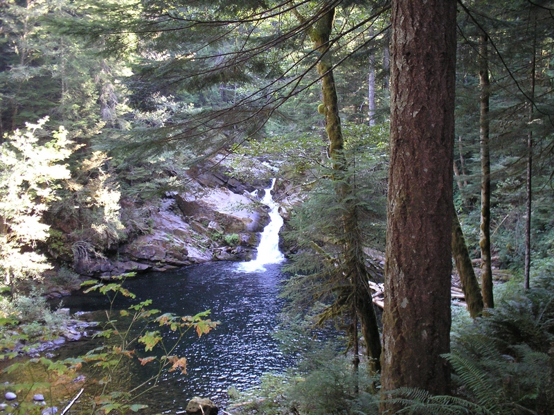
Continuing on the trail, in another 1/2 mile or so, the trail takes a turn up horse shoe creek for a short way. This is one of the more interesting parts of the hike, besides the fact that the whole hike is a beautiful forest hike. The creek here is very narrow and serpentines down through the bedrock in very deep clear pools. This is a nice spot just to spend time relaxing and enjoying. There is a small bridge that crosses the creek, and a deep pool under the bridge that when you look at it, looks as though it could be 8 ft deep, though the creek is only 5 or 6 feet wide at the widest spot. There are numerous small water falls on the creek and 1/4 mile down the trail there is a short trail to a view point where you can look up the creek at all of the small water falls cascading down. Continuing on, there is a larger falls on Souxion creek that spills into a large emerald green pool. The falls is not very big, but is still very impressive tumbling down over the rocks and into the green water below. The water looks green because there is a thick carpet of alga on the bottom. The view of the falls and pool is from an embankment a good 50 ft above the water. The spot has a nice single bench for sitting and contemplating. To the northwest of the trail is another area people use for camping, this is a very popular spot and there is almost always someone camping here in the summer
The trail when observed on the USGS map of the 50's runs further away from the creek, and it would be interesting to find the old trail some time. As the new trail continues on, you can ascend to the top of the falls, a nice place for a snack. You can look out over the water, it is cool next to the stream which runs through large angular stones. The trail passes another smaller falls and pool shortly, and then climbs a little bit. I continued on another 1/2 mile or so to the junction of wildcat trail head and the return of the horseshoe trail. Here you can ford the creek and make the climb up wildcat trail, about 3 miles to Souxion peak
This is where I turned around and headed back. The trail to this junction is slightly over three miles with an elevation gain of just over 200 feet. A very nice easy hike. Of course when you return to the trail head you end your hike with the steepest part of the hike, a 1/4 mile of 20% grade
When you leave the valley, be sure to stop and take a look back over the valley, you can see horseshoe ridge and get an idea of just how far you were up the valley.