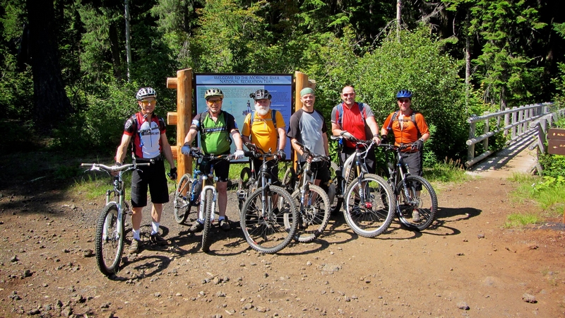
I shot a text to Paul Norris asking if he wanted to ride on Tuesday and he responded with Sandy Ridge.
The Sandy Ridge trail system is designed with downhill running as the primary focus.
The trail system is accessed by climbing a paved road, which is gated off (although there is a sign warning of possible vehicle traffic). A constant grind the climb is a good three plus miles.
Paul and I took off like it was the Wednesday night road ride; let's see how fast we can get to the top. I pressed it hard for the first mile and a half then had to throttle back.
By the time we reached the trail system I was gassed. I took a couple shots on my energy drink and we started cranking out the new connector trail that led into Rock Drop Trail.
The connector was well laid out. The tread was a mixture of dirt and gravel. I was surprised at how much gravel there was, it affected the bite but the trail was not flat and manicured, it was a nice rolling line that followed the terrain as it twisted and turned its way through the forest.
This is a black diamond trail, but it can be rolled. I would not want to ride the line on a weekend, since I would just turn into an obstacle to be dodged by the armor clad warriors on their forty pound steeds. But on such a nice early Tuesday afternoon, there was no one there but Paul and me.
We blasted down the trail, hopping up onto the table tops and skidding over the trail kickers to fly up the banked corners and rollers that were presented as the line traced a path over the man made features and took advantage of the natural features at every opportunity.
Even this old guy was forced into the air a few times, my heart racing as I heard my front tire skid as it touched down.
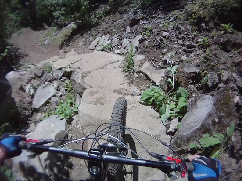
The Rock Drop was a short three quarters of a mile that had me grinning from ear to ear.
The trail flowed from Rock Drop to Quid Pro Flow, which was anything but flow at the start.
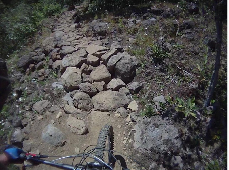
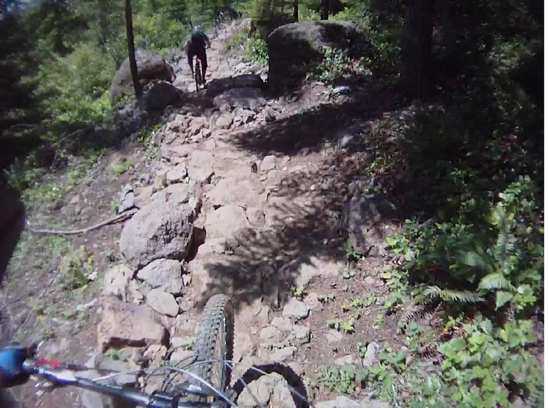
The trail turned from smooth fast undulating terrain to a rocky chunky rumbling line.
Quid Pro Flow starts with a rock garden, the rocks are very uniform and the tread, although rough, is very ride-able.
The trail rumbles up and down as it traverses a hillside, offering up root and rock drops before presenting the next rock garden.
The second rock garden is much more challenging then the first, It is more a jumble of stones and I think it would require a few more attempts before I would find the right line. It pulled me from my bike in three places, one of which was right at the beginning so a restart allowed me to clear that section.
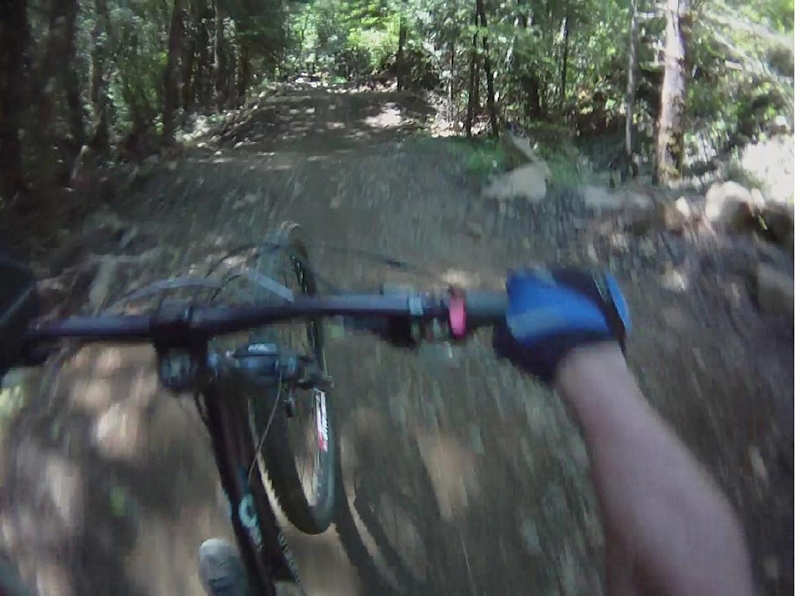
The line continued to traverse the hillside, with more root and rock drops and rolls until it flowed out into an old skidder road where it transformed back into a jump line, with lots of small kickers and big banked corners.
Screaming up and over large rollers and flying around the swooping fast berms my legs were burning as I flew through feature after feature.
I was actually happy to see the line flatten out as it ended in a grove of small deciduous trees and I coasted to a stop to shake the numbness from my hands.
The return line was a climbing line but laid out so that you climbed to gain a short bit of elevation, then descended to give you a quick short break, to return to the climb and repeat the action. This approach works well, allowing you to take the climb in short interval bursts and the short blast of descent allowed you to carry momentum into the next ascent.
There were lots of root ups and natural features to challenge me as we pressed the ride back to finish the loop which ended at a junction with the Three Thirty Eight Trail.
The Three Thirty Eight Trail was a climbing trail and a lot like the return line we had just ridden but with a little more sustained climbing, all at a low angle of ascent.
After about a half mile we came to the junction with the new trail Two Turntables and a Microwave or TTM.
I have been here one other time and this trail was not in at that time. On my first visit we continued on around on the Three Thirty Eight Trail and repeated the Quid Pro Flow before returning and descending on Hide and Seek.
The Hide and Seek trail from its junction with Three Thirty Eight to the creek crossing is just one rock or root drop after another. It is a very technical descent, even though the trail is considered a Blue line.
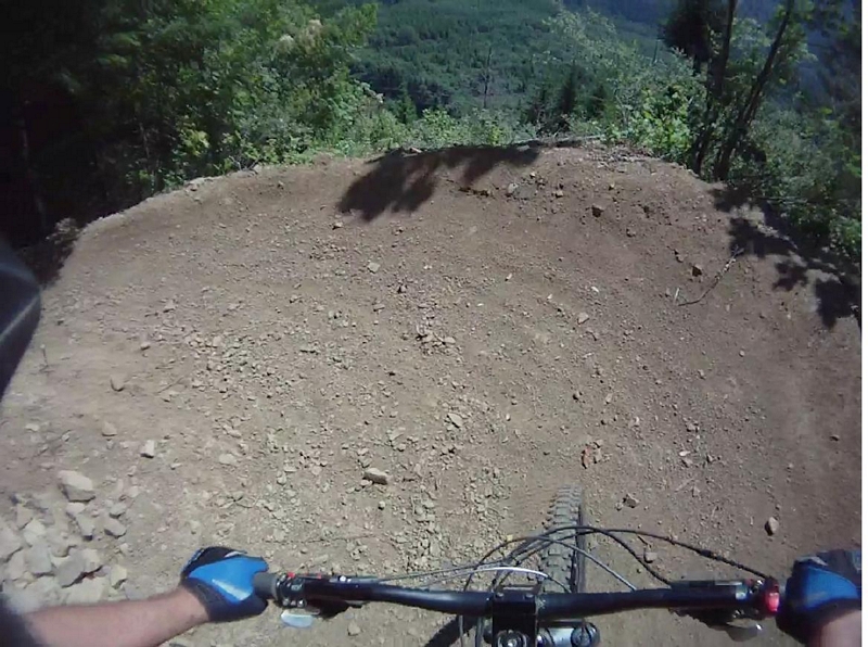
Now the new line, Two Turntables and a Microwave is a Black Diamond line.
The trail starts with a big rock drop that is really more of a launch for the young guys in full face helmets and armor.
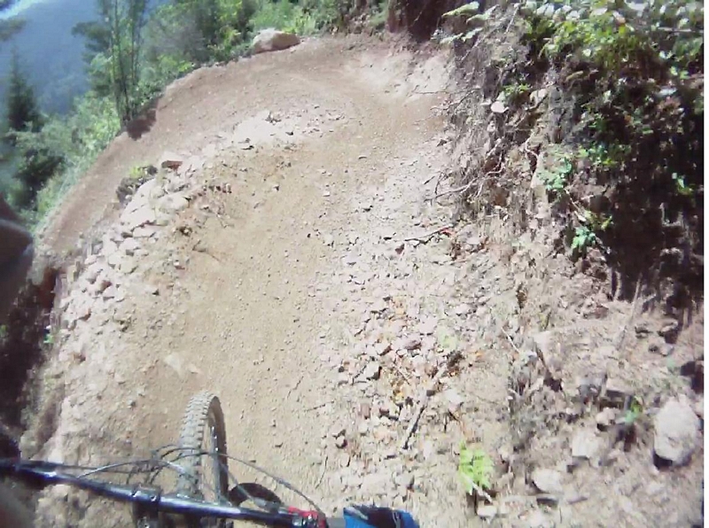
We rode around the drop and the trail immediately presented a large banked corner that was followed by another banked corner and into a series of banked corners as the line dropped quickly down the steep hillside.
After a half dozen corners the trail started to traverse the hillside and presented a series of rollers or kickers.
The tread was a mixture of soil and rock, fist sized rough angular stone aggregate mixed with the soil to make a firm but fast tread.
It was like a roller coaster, fast screaming fun that forced me to stop a couple of times to let my legs and hands rest.
Every corner was a berm and lent itself to railing high to carry your speed into the next section of rollers and kickers.
I would always choose this descent over the Hide and Seek descent. Hide and Seek works you hard through the never ending root and rock drops as the trail descends across the face of the hillside.
I don't think I turned a crank, except to change my lead foot, until I reached the bottom of the trail.
The only really scary thing about this trail, besides the exposure in a couple of places, is that on a week end or even in the evenings during the good months, there are going to be some real fast riders hammering down this thing, but I guess that can be said for most of the trails up here.
The Two Turntables and a Microwave Trail junctions with the Hide and Seek trail just before the creek crossing.
Picking up the Hide and Seek trail at the bridge, it climbs up a moderate grade for a very short distance, offering an out to the paved road when it crests. The out provides a way to climb back up to the top of the system if you are so inclined or a way to climb up to here on the road.
Lower Hide and Seek is just what upper Hide and Seek was not, fast and swoopy.
Paul and I cranked our way up the trail until it broke and started the descent. The descent was fast and within seconds Paul started pulling away, blasting down the hill, weaving through the trees on a bermed line.
As I approached the first switchback I could see Paul flash by through the trees, going the other way.
A couple more switchback as the trail descends, the dirt in the trail holding enough moisture to provide perfect tread.
The trail was fast but there was one corner in the first few that was chunky and had no flow at all for me as I dropped off a large rock and had to dab to keep my tires on the line.
More fast corners, bermed for speed and into an area of the trail that had seen a lot of work, pavers have been planted in the line. They look like a lattice brick and they are about a foot wide.
The pavers are laid in three rows and form a steep bank that provided a path to rail high into the corner. There were a couple of sections where the pavers would form two, three, or four corners in a series.
The line along here also provided some straight sections with small kickers and rollers to catch some air.
The trail dumps you back on the Homestead road where you can elect to climb back to the top, climb to the point halfway up and ride Hide and Seek again, or cross the road and ride on down to the bottom of the system.
The last section of Hide and Seek has a short three quarter mile trail called Laura's Loop, looping off of it.
Laura's Loop is a smooth broad trail which winds up a mild grade to break over the top of a wide ridge and gives a nice fast rolling descent that does not require any technical skill.
There are two ways to get to Laura's Loop, ride up Homestead Rd until you reach the Hide and Seek crossing, or ride up Hide and Seek. The latter is a more technical line.
I think it is interesting that they would build a green trail that can only be accessed by riding a blue trail.
Sandy Ridge has some great riding, but I think it has been designed and built with the downhill rider in mind. There are no climbing trails per say but there is climbing on some of the trail although no sustained climbing except on the pavement and all trails are accessed via the road.
Thunder, lightning and brambles
Since my friend Bob Horness has signed up for the fifty mile race at Capitol Forest, I suggested we ride one leg of the course on Friday. We had ridden part of the first/last leg a couple of weeks ago and found it to be a disgusting mess of mud and manure.
Friday usually finds me, Barry Desemple and Bob riding on local trails, since this is one of Barry's days off. Alex Sandrow also takes Friday's off and asked if we would be riding. Alex posted a ride inquiry for Friday to facebook so he joined us for the second leg of the Capitol Forest fifty.
We met in the parking lot behind the Kelso McD's to carpool the sixty five miles to Capitol forest.
After a change of clothes and making sure we had all of our equipment together, we headed up the Green Line trail #6 to the Mima-Porter trail #8. The sign at the trailhead indicated a 6.6 mile ride to Wedekind Picnic area.
The tread was almost perfect. The weather had been warm all week, in the lower to mid eighties but with a cloud cover through the morning and the trail reflected that. The soil was still holding some moisture so there was no dust but there were also no mud holes. We rode across places that were gooey, like dough but nothing wet.
The line started with an easy climb up through timber for a quarter mile or so until we turned west onto the Mima-Porter trail.
The trail ran for about a third of a mile on a nice three to four percent downhill grade.
It was a fast rolling line that swooped through the woods and crossed an aged clear cut. As the trail ran through the clear cut it was lined with purple fox gloves flowers fully bloomed with a few white ones sprinkled in and patches of white daises all in a backdrop of dark green underbrush and ferns.
The trail hit a gravel double track for a hundred yards then turned back into the timber to start a long climb.
The climb was steady, a lower mid-range grind that had a few spots that required a shift into low gear or some extra oomph to clear a short steep.
The trail ran in and out of the timber but mostly climbed through clear cuts, twisting and winding, climbing over five hundred feet in a mile and a half.
The line finally broke into a flat and downhill run for a very short ways as it entered big timber and started the next, easier climb over the next four miles on a three to four percent slope.
The trail ran around a ridge cutting a wide line into the steep hillside, traversing a slope that approached forty five percent, to follow a line that took it deep into a rugged valley and across a stream to turn and head back out and around the next ridge, repeating this process a half dozen times on the climb.
A crack of distant thunder rang out; I was surprised since I was expecting the day to be like the other days this last week, overcast turning to sunny.
We kept cranking out the miles, breaking into a young clear cut where the steep hillside we were traversing became so much more apparent.
Bob pointed off toward the southern horizon, noting a logging operation a mile or two away across the deep valley. The hillside scared with long strips that stretched down the face of the mountain, created by the high lead logging operation going on there.
The open area we were standing in had seen its own scaring recently. The large roots of the harvested timber still stretched across the trail forming rise after rise to bounce up over as we climbed.
We crossed out of the clear cut and back into the woods to find a trail junction. The trail markers indicated we had covered a little over four miles in the last hour of climbing and had another couple to go. The junction presented a connector trail, trail #50 that cut across to the Green Line #6 and up to Capitol Peak, or down and back to where we were parked. It was a possible option for a shorter loop ride.
The thunder cracked again and sounded much closer. We continued turning pedals and climbing up the trail.
A heavy mist was in the air and it felt like it could rain at any time. I had left my rain coat at home and was a little concerned since every time I hit a little down slope on the trail I could feel the chill. This was how people over extended themselves and got into trouble. If it were another ten degrees cooler, the potential of hypothermia could come into play.
We continued across another young clear cut and through the woods, crossing a bedrock stream. The crossing facilitated by some logs that had been laid across the creek so using your bike as a crutch the crossing was simple.
Barry and Alex scoped a line that they talked up as ride-able. I just made note that there was also a twenty foot drop where the trail crossed the creek so the penalty was big.
About five minutes later and we reached the gravel road that was the C-line.
Bob spotted a trail, across a spur road that came off the C-line and headed for it. I was busy pulling maps out of my pocket to check our location and verify our course.
I shouted out to Bob, asking if there were any trail markings as I checked my map. According to the map, we needed to head down a spur road that was across the C-line and the trail we wanted would be just a few hundred feet down on the right.
This would be a departure from the race route. The race was going to make use of the gravel road, the C-line and road C-4000, for about six miles along here.
Everyone seemed to be headed in different directions here so I headed down the gravel spur road and shouted out when I saw the trail.
A sign at the trail head indicated it was closed to horses. The trail curved around a corner and turned sharply up hill, I was in a mid range gear and started cranking hard.
I was up out of the saddle, leaned forward and cranking hard, climbing into another turn that presented more steep climbing so I stopped.
As Barry and I pulled off the trail, Bob came by, tearing up the trail. A determined look on his face and in his favorite gear combination of middle ring gear and large sprocket, he poured the power to it and within seconds was out of sight.
I could hear my heart thumping in my ears as my gasping for breath subsided. I picked the back of my bike off the ground and kicked the pedal around as I shifted down to the small ring gear. Pulling my bike across the trail, perpendicular to the line, to mount it on a level stance and leaned forward into the climb.
It was a long climb, a good half mile on a ten percent grade. It is the kind of climb that makes the front end of your bike so light that it dances back and forth as you grind out each pedal stroke.
As the trail finally started to level off, I could see Bob standing alongside the trail, his water bottle in one hand, grinning at me. "Damn this f'in thing just keeps climbing" I gasp out on my approach.
The connector trail, trail #30, we were on junctions with the Green Line #6 trail. The signage indicates it is just about four miles to Capitol Peak, where we start the downhill run.
A look at the map tells me we will be running up and down along the top of the main ridge, the ridge that all the others form off of.
The trail is overgrown and although it is not raining the wet brush is soaking me down my arms, legs and shorts are soon wet. My shoes are shining wet and black.
This section of trail is a mellow downhill, could be very enjoyable but the brush is a little distracting.
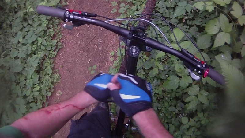
We hit the gravel again and crossing it we continue with some easy climbing and descending. The brush along here contains a lot of brambles and I keep pulling back on my right side, trying to avoid contact as much as possible.
When I looked down at my arms, I noticed that there is a stream of bright red blood running down my left arm, down and around my arm, into my glove. I had to stop and pull some tissue from my pack. Cleaning up my arm, there was one gash pretty deep and I had to apply pressure to stop the bleeding.
Later Alex would say "I was getting scratches in the scratches" and the next day he posted this to facebook "Anyone else look like they got taken out back by a pack of Alley Katz yesterday? Legs aren't too bad - but DAMN are my arms shredded!!!"
The tread was decent along here, firm packed dirt with a few rocks for a little rumbling action now and then.
We got a little spread out through the brush and brambles, but ended up regrouping at the base of a very stiff climb, not a long one but a bottom gear stiff climb that had my heart rate at red line by the time I cleared it.
Another clap of thunder that sounded very close, and then a few minutes later as we were approaching a peak on the ridge, the sky lit up with a bright flash and just a few seconds passed before the thunder rang in our ears.
Bob looked at his bike and said "better get this lightning rod off the top of the hill". With that we were all screaming down the back side of that ridge until we reached a gravel road.
Across the road we picked up the trail again and followed it to the C-4000 road where the Green Line #6 takes a turn downhill, on a very steep descent.
It was wet; the rain had started, although it was light it was wet.
This descent is not for beginning riders, the steepness and technical challenges are in the intermediate to advanced rider category.
Since I knew I would not be hammering down this line, I stopped and let the others take the lead while I wiped off the lens on my camera. Barry and Alex took off first on the squish bikes with Bob following close behind on his hard tail 29er.
The descent starts at a fast pace with a couple of root hops and rollers that lead into a hard switchback.
The tread still firm and smooth, the line heads down to the second switchback where there is a caution sign. The corner is very sharp and has been built up. It is a flat corner and there is a rail, made from local resources, it is about a foot or so off the ground. I don't think it could stop you but it clearly shows the edge of the trail.
As the trail drops into the next switchback the tread starts to get a little rougher, there are a couple of big root drops along the line as it makes the switchback.
The trail descends almost five hundred feet over three quarters of a mile through a dozen or so switchbacks. As it descends there are plenty of technical root drops and rocks to keep you on your toes.
The line serves up a short uphill section of a quarter mile of so, nothing too strong, just some nice single track with a few root ups and a little rock. There was one spot that did catch me, a slick (since it was now raining) little steep that I should have been able to clear in a half dozen pedal cranks but after a couple of slips I had to step off and push a couple of feet.
The next half mile of steep switchback descent is filled with root and rock drops as the trail winds down through the clear cut.
This section lends itself to speed, the harder you hang on the faster you can go, most of the corners are dug in and bank through the turn, a full suspension squishy bike will perform excellent through this and other sections of this descent. It does pound you though, especially if you are riding a hard tail.
The bottom of this run junctions with the trail #50 that we had seen on our climb. This is also the place where the race is going to turn onto trail #50 and exit to gravel for a couple of miles instead of taking the Green Line on down to the gravel road.
A short ways down the trail there is a split in the trail that offers a short steep climb to roll over the top of a large mound, shoot down a steep on the other side and hit a small kicker or to ride around.
A short ways on the trail leaves the clear cut to return to the timber, the line gets a little more technical and we are back into a section of root and rock drop descent.
There is not much pedaling through here, mostly keeping your weight back and picking the line that is going to please you the most, whether it is to hit the drops hard or rail around them, there are plenty of options to match your speed and style through this section.
After the line drops to cross a stream and climbs up a short climb, the track starts to mellow.
A run back out through a clear cut, the line is fast and approaching smooth.
Then it takes a turn down hill again but not as rough as before. It drops and cross the C-line.
The descent is not as radical, the root and rock drops smaller and smoother; the trail starts to scream.
For us on this day, the rain has started to pour and the tread has started to get slick. The descent has smoothed out radically and we rip down through a tunnel in the brush cover, the only thing visible is the line.
Another break out into a clear cut, stopping for a moment to survey the surroundings, Bob leads off and we again blast across the clear cut on a fast track.
Blasting back into the woods the trail keeps serving up fast corners and quick shots down a hard packed line.
The trail finally hitting the bottom of the run as it crosses a creek on a small bridge and turns uphill for a short but steep ascent.
I can see both Barry and Alex pushing their bikes so I make a quick shift on the sprocket to the large gear and leave the front on the center chain ring and hammer it up the hill.
Quickly turning back downhill, the trail is super smooth single track that is running almost straight. A few easy wide corners and I find myself sitting back, seat dropper down, resting my weight on one thigh as I fly through the lush rain forest back to the parking lot.
Back at the car, I look down and see the muck accumulated on my bike. The last time I was here we found the bike wash, so I hop on my bike and coast down to the stream to rinse my bike and I am soon joined by Bob.
Back at the car, everyone is grinning ear to ear, the rain has stopped and the temperature is comfortable. I again had not even thought to bring a towel, so Bob offers me one side of his. After a quick wipe of my face and beard I see I have left a muddy impression.
We change, share a couple of Vortex craft beers in Dixie cups while eating lunch and head out.
Mountain biking the McKenzie River Trail with the PhattyPuss Crew
Alix Sandrow put together an event, to ride the MRT, on Facebook and invited a group of riders that he dubbed the PhattyPuss Crew. He scheduled the ride for the seventh of July.
We worked out the logistics of camping or lodging and contracted with a local service for shuttling the crew to the top of the trail head.
Three of us, Bob Horness, Barry DeSemple, and myself were camping at the hot springs. It was located on the McKenzie River Trail and about four miles from the lower trail head. The shuttle service was to pick us up at the trail head at ten in the AM on Saturday.
The ride from the hot springs started with a mellow climb, a mid gear range chug up the hill to break into a nice fast paced descent.
The descent had a few sketchy spots that might be a bit intimidating for a novice rider. A couple of places where the trail narrowed significantly as it passed by a large rock, then again after turning a very tight and somewhat exposed switchback the line skinnys past the crook in a tree.
After the trail crosses a large creek it climbs around another ridge and starts a mellow fast run for the next few miles to the lower trail head. The track is mostly smooth and fast with lots of serpentine action.
This portion of the trail is normally the end of the ride, and those couple of moderate climbs become more challenging as your energy wanes.
Bob and I had ridden to the trail head and back the night before and knew how long it was going to take us. The departure was scheduled for ten and we were a half hour early.
The van showed up right on schedule, we loaded up and transported to the top of the 26 mile trail.
From the parking area, the trail starts just a few feet down a double track. A large sign welcomes you to the McKenzie River National Recreation Trail. The sign located right next to the bridge that is the start of the trail.
The first mile is blazing fast smooth single track that takes you to a bridge and an option. Cross the bridge and travel down the East side of the lake, a technical line that cross a couple of large lava fields or continue on straight ahead on the West side of the lake and continue to enjoy the fast smooth single track.
I have been down both sides one time. The East side of the lake was very slow and technical. I was with a very large group and almost everyone was walking their bikes. This group might have been more adept at riding the lava but I knew we were going to be seeing lots more of these technical challenges over the next ten miles.
We screamed down the West side of the lake, a few short climbs but overall the track was smooth and fast.
There is a section of cabins near the end of the lake. The trail continues at the other end, past the dock and up a slight incline.
From the trail head to the end of the lake was about three and a half miles. There is a bridge over the outlet of Clear Lake which marks the transition from smooth single track to the start of more technical riding in the lava.
The water here has an emerald green hue and is crystal clear. The old submerged logs, rocks, and algae clearly visible.
There were a half dozen ducks sunning themselves on a log that was floating nearby.
I have read that further out in the lake there are submerged petrified trees from the forest that was here when a lava flow blocked the McKenzie and formed this lake, around three thousand years ago.
From a row boat the trees can be seen through the clear water since the visibility in the lake can be up to 200 feet; remarkably clear water.
The smooth track has turned into smooth track running through old lava, a lava flow that has a mature forest growing on it.
This is also where the East and West lake trails converge and it is easy to miss the dark brown sign that indicates which way to go and end up heading around the lake.
The trail flows nicely through the lava, under the canopy of very large Doug fir. There is one significant challenge where the trail takes a turn around a large fir tree which presents a huge root on the turn.
The trail crosses a forest service road and runs through the trees next to highway 126 for just a few feet before it turns to cross the highway. An easy place to get confused and a place to be aware of your surroundings since the traffic is flying by at sixty miles an hour.
The trail parallels the river on the east side for about a quarter mile to a foot bridge that crosses the river.
The tread had become more challenging and I stopped at the bridge to put on my armor, consisting of knee and shin guards and forearm and elbow guards. I was the only one using protection. I knew the next section was one of the most technical on the trail, lots of rock drops and tight turns.
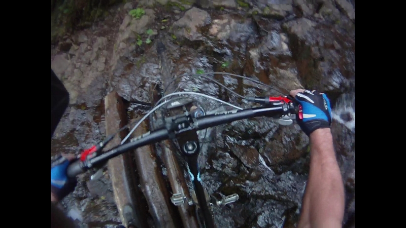
We cranked along the trail that was traversing a steep hillside then over a set of stairs that were built to cross a giant fir log that had fallen across the trail.
A turn in the trail forced everyone from their bike as we packed them over a lava outcropping, the roar of the river rang in my ears as it passed just a few feet below us.
This was followed by a short climb up a very exposed section that pulled me from my bike near the end. The line climbed over roots and lava; there were large lava formations sticking out from the hillside and portions of the benched trail supported by timbers as it hung above the river.
The lava imbedded trail continues high above the river following the ridgeline in and out, up and down as it approaches Sahalie Falls.
The group had gotten spread out and Lee and I stopped for a second, if only to notice they had blown right by one of the most impressive waterfalls on the McKenzie. The trail did require all of your attention so if you didn't know you could easily pass the falls.
As the trail started to descend I had to stop for a second to watch the torrent of water flow over the top of the cliff and plunge to the river bed far below.
The trail moved back away from the edge of the ridge to descend through a very technically challenging area.
No sooner did we re-start our descent than we came across a group of hikers. It was a large family group of fifteen or more that were hiking in the same direction as we were riding. A rough rugged section of trail that did not lend itself to us passing so I would descend through a section, making a switchback or finding a flat spot where I could stop, stick out a foot to brace myself and wait before taking on the next section.
Soon we reached a point in the trail where it flattened out a bit and they stopped to let us go by.
We came across more hikers, but all of them going up the trail. We yielded for each group.
Back down to the river, we continued to weave around boulders and bounce across lava rocks and roots as the trail followed the river's edge.
The trail was still technical but now more in small chunks it has you rumble through a short section or power up over a small knoll to crank a few pedal strokes across the forest floor on compacted dirt and fir needles.
And just as I was starting to cruise along, we hit a nice technical descent that forced me from my bike for the first three feet. The line of decent was down a steep chute of sorts, the hillside on the right and a large log on the left with a sharp turn at the bottom. I remounted and with my weight back over the rear wheel, descended down over the rocky steps.
The rest of the crew had reached a trail junction just above Carman Reservoir and were waiting for us there.
We all headed off on a much buffer single track than the last mile and a half.
The trail climbed some and traversed a steep hillside, with the reservoir visible as a blue background through the trees.
Then the line dropped down to run across a much flatter course where the brush was thick and hanging over the trail.
As we rode the trail, we would catch glimpses of the dry riverbed. The McKenzie River disappears underground for a few miles. There is a visible river bed where I am told it does run at times during the winter or high water season.
Crossing the dry river on a bridge we are just over six miles and slightly over an hour into our journey.
We enter yet another segment of the ride, across a large field of lava. The lava supports a forest of very large Douglas fir and for the most part the trail is smooth single track with an occasional section of rumbling lava rock.
I have personally always enjoyed this section but it does have some technical challenges.
I had a friend from the old PUMP club days tell me he would not ride the McKenzie anymore because on his last trip he came across a rider down in a lava hole along the trail, somewhere in this section I do believe. The rider was severely injured and someone had to go for medical help. He spent the better part of the day supporting and providing first aid to the rider.
We took a short break at the bridge, then I jumped in front to see if I could set a pace that might be a little below red line on my cardio gauge.
The trail runs for the next two and a half mile across an undulating landscape. The line rolls up and down, flowing through the forest with lots of short rumbling lava rock sections.
The whole area is one big lava flow but it is so old that the forest floor now covers it so the tread is smooth and fast until you crest a knoll or swoop around a corner to be presented with short section of lava rock and you have to quickly pick your line.
It seemed like the closer we got to the Tamolitch or Blue pool the more rugged the lava became.
We stopped after twenty five minutes and had a snack at the Blue Pool. It is hard to describe, you are up on the top of a lava ridge, the McKenzie River has just burst back out of the ground and the water is crystal clear and an azure to cyan blue. A striking blue color, the river roars away down the gorge it is in with the trail now following it at the top of the ridge.
There are many places along here where the sides of the gorge are vertical and large flat stone features present themselves as viewpoints, exciting beautiful and scary.
The next section is the biggest challenge of the day, in my opinion. Many would say that the upper section of lava trail was the most difficult but for me the biggest challenge is the next mile.
The tread is almost pure lava rocks and gnarly tree roots. The trail winds back and forth while climbing and descending in short bursts, mostly descending.
The trail starts by delivering up a hard, but doable climb to flow across some smoother lava and descend through a small ravine, the bottom of which is firm but filled with sharp jagged lava chunks then it makes a sharp turn at the bottom.
For the next fifteen minutes the process to some extent would repeat over and over.
Besides the grunting and wheezing sounds I was making there was also this loud pinging sound from my tires as the knobs on the tread caught and broke free from the sharp lava.
I had to put it all out there on the climbs and pull it all back in on the descents.
It was a crowded day and I stopped at least a half dozen times to let hikers ascend through the narrow gorges and ruts that made up the majority of the trail.
Finally the trail returned to the river to run along the edge for a half mile or so, much easier than the lava but still challenging as the line wound through the big trees, over roots and rocks to finally climb back up to cross the road that lead in from Trail Bridge Campground.
From there the trail climbs at about a seven percent slope for about a half mile. Not a hard climb but after about two and a half hours I am feeling it.
The descent is hard and fast at a nine percent grade, the trail traversing the steep hillside on a narrow line that blasts down the hill.
By the time I reach the bottom my hands are starting to cramp, the two fingers that hold the handlebars on each side pulling in tight as the muscles in my forearm contract. I don't fight it and try to relax as I coast up to the water spigot at Trail Bridge Campground.
I pushed the button on my handle bars and my seat drops five inches allowing me to sit astride my bike. I am able to pull some electrolytes from my pack and swallow them down, I know that I had too much alcohol to drink the night before and didn't hydrate well on the ride. Pulling the bladder from my pack I see that I have only drank about twenty ounces.
I open the bladder to add more water and Alex asks if I would like some fizzes (an electrolyte product that you can add to your water to keep your electrolyte levels higher). They have a nice grape flavor and I try to get as much water as I can into me.
After a few minutes in the shade we hit the trail.
It is a short descent to cross a creek then a hike a bike up a steep bank to gain the trail.
The trail climbs up the side of a steep hill while circumventing it.
After grinding out the climb, which had a couple of very exposed spots and a short section of spring feed muck, the trail starts a fast descent.
A quick stop just after the Trail Bridge Dam and the guys hit it hard, I am still feeling a little weak so I roll the trail at a nice moderate pace. The tread is solid with just a sprinkling of roots and rocks.
Stopping every ten minutes over the next half hour I slug down as much water as I can and swallow a couple more electrolytes.
I catch up to the crew at Deer Creek Foot Bridge. Everyone is hanging at the edge of the creek, cooling off, Aaron's was lead rider and his face is a bright red and I know that Bob was right on his back tire for the whole three miles.
The whole crew slows the pace a bit for the next couple of miles, but soon after that we are spread out again, everyone riding at a pace that is good for them.
Every ride I have done here seems to go that way, some of the riders still have a lot of fuel in the tank and this is a good spot for flying single track.
Three and a half miles brings us to the road where the trail crosses over to the south side of the river. It is a spot where on my first ride I spent an hour following fisherman trails down the north side of the river looking for the trail. Since then the signage has improved.
I am riding by myself at this point but after a short ways I find Alex has stopped to wait for me.
We ride on for another mile and hit the Belknap hot springs where I am camped. Alex has another four plus miles to ride to get back to the parking area and it looks like the others just blew on by.
Alex rode down to the lodge with me but after seeing the others were not there we part ways, Alex heading for the finish to his ride and me heading to the camp.
It was a twenty six mile ride.
We left camp at eight forty five and I was back at just before three in the afternoon.
My video time works out to four hours and forty five minutes on the trail.
Bob Horness is trying to get prepared for the fifty mile race at Capitol forest so he continued down to the lower trail head and back to add about nine more miles.
Barry rode on just a short ways and decided he had enough and backtracked to camp just shortly after I arrived.
