
Mountain Biking Three Corner Rock Trail
Difficulty: Extream Climbing, Areas of Exposure
Suggested Skill Level: Advanced
Trailhead longitude and latitude: 45 42 7.5N, 122 07 17.29W
Google Trail Head Location
 Google Directions From Portland
Description of Ride:
Three Corner Rock, switch back boot camp.Paul Norris picked me up at the park and ride in Woodland, 6:00 am. We were turning cranks by 7:30 am.
The trail starts off climbing 400 feet through five switchbacks to break over the ridge at 1300 feet. The tread was nice forest floor, firm hard packed dirt with a few roots and rocks. Lots of ferns and salmon berry in the under story but a very clean trail with a moderate width. The line weaves back and forth across a very steep hillside.
Then it descends back down 300 feet in just over a mile through two more switchbacks. The track is still firm hard pack with a few stones. The line overall was about a 6% grade that had a few steep sections. The brush was overhanging the trail to a minor extent, slapping me with a few wet spit bug branches as I flew by.
The next climb is a simple 835 feet over one and a third miles, which comes out to about a 12% grade on the average. With just 16 switchbacks, most of which I had to get off and walk around on the way up clearing maybe 3 or 4 of them. The right turn switchback seems to agree with me but the left turns never did. It seemed also that the left turns were almost all covered in loose stone, the approach almost always seemed to get steeper just before and after the switchback.
The line turns down with six more switchbacks and almost a mile of descent. The trail is another 12% grade to the stream crossing. I am still having problems with the switchbacks on the way down and most of the now right hand switchbacks (left hand going up) were giving me the most problems. Most cases found me riding high on the bank before the turn and just dismounting and spinning my bike on the back wheel, then flipping my leg over and start blasting down toward the next switchback.
Finally there is a very short climb to break over the shoulder of a small ridge and drop down to a tributary that feeds Stebbins creek.
This is a good place to turn around and head back for a great ten mile out and back. A spot, where according to the reports I have read on line, is impassable during parts of the year when the water is running high.
The stream on our ride was very low and easily forded. Using the bike as a crutch technique we just stepped from rock to rock and prepared for the next ascent.
We left the steam with a very hard pull up through the first of nine more switchbacks over the next mile.
We were cranking our way up through a section of trail where the tread has turned to loose rock, one or two inch and smaller in size. One short rocky exposed section to cross where the tread turned into a rock garden. I looked the line over as I walked my bike through the rock garden, looking for the best line on the descent and when I hit it on the return run, I had picked a high line, but my back wheel washed out on the loose gravel, turning me sideways and I ended up walking it down.
Finally hitting the top of the ridge, we took a short break with some silly talk about turning around and calling it good, which would make it a twelve mile out and back. Unfortunately the line ahead of us had leveled off in slope which just forced us to proceed.
Now running at about a two to three percent grade the trail rolled along the top of the ridge. There is lots of shifting up and down along the next mile to accommodate the short steep pulls that transition into a fast run out across the side of the ridge; most of the track was a smooth forest floor. Although there were a couple of sections toward the end of the trail where it looked like a stream had jumped a bank and ripped down the trail, exposing very large stones and root drops.
Since leaving the creek, the vegetation along the trail has become more overgrown primarily with salmon berry and huckleberry brush encroaching on the line. My arms have multiple small scratches that display themselves as little red lines.
When we reach the road, the question of continuing to the top goes unspoken. We ride uphill on the gravel looking for the road and after a few hundred feet; check the map to see it is just below the trail exit.
We were on the final push to the top, one and three quarter mile with 18 switchbacks.
The tread on the climb to the top became progressively rockier. Starting with some firm dirt and rock mix and progressing to rock and rubble.
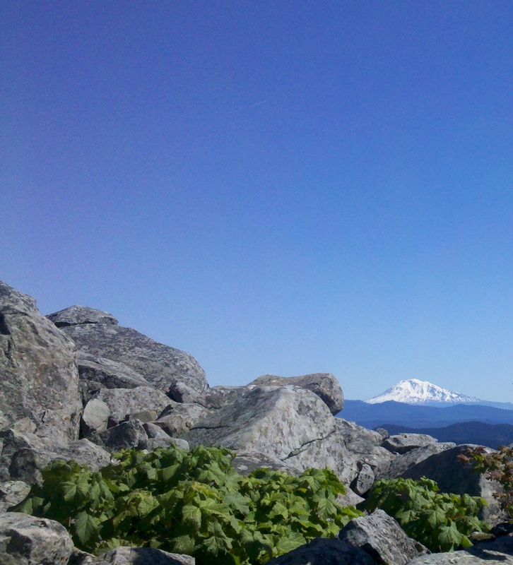
When the trail breaks free of the timber there are some great views of the valleys stretching out and away into a hazy blue horizon. The timber has been replaced with an expanse of wild flowers and brush.
About a half mile from the top the vegetation became so thick that the track was not visible. Pushing our bikes for the next quarter mile to a point where we just gave in and left the bikes to hike the final quarter mile to the top.
Three Corner Rock is not a rock. Like the tip of an ice berg thrust up out of the surrounding sea of timber and brush. The formation is composed of a huge pile of large angular stones that roughly take the shape of a three sided pyramid.


The view from the top is marred by a large relay tower that stands on the hill just a couple thousand feet away from Three Corner Rock. There is a gravel access road that also passes by and access up and onto the geological feature has been developed by or for jeeps and other vehicles.
That aside, the view to the north is spectacular, Helens, Rainier, and Adams are all stretched across the horizon.
The descent down to the road looked to be a bit sketchy. On the way up both Paul and I noticed a couple of very exposed areas and I was uncomfortable with all the tight switchbacks on the loose rocky material.
Paul, loosened his seat clamp and dropped his seat as low as it would go, then dropped the gravity seat to the lowest position. I have a dropper seat on my bike, a simple style dropper that is activated by reaching under the seat, pulling the leaver and shifting your weight forward causing the seat to drop about four inches. I rarely use it because of having to take your hand off the bar and reaching under the seat. Once I break into a steep descent, it's not very handy to be steering with one hand.
I lowered my seat with the dropper as low as I could get it before we even started to descend. Sitting back on the saddle, I felt like I was riding a BMX or trials bike; not really made for cranking while sitting.
Starting down through the next quarter mile of thick brush was an exciting challenge. I started by ratcheting the pedal around to take a bite out of my shine as I struggled to get rolling. A trough in the vegetation guided me down to the first switchback, a turn that I made with one foot on the ground as I pivoted around and continued plowing my way through the thick brush.
Pretty soon I started seeing glimpses of dirt as the vegetation started thinning out and the angle of descent started to increase.
Applying pressure to the brakes and sliding back off the seat to stand on the pedals, my weight back and low, I approached the first open switchback. I dropped the outside pedal down and leaned toward the switchback as I turned the bike. With my inside foot off the pedal, I steadied myself as I turned the corner and moved back into a descending stance.
Switchback after switchback I used the same technique. The saddle lowered down made all the difference. It was out of the way and not likely to slap me in the ass if the back tire hit a rock or root in the turn. It made all the difference in making the corners and giving me the confidence to turn a trepid descent into an exciting experience.
Eighteen switchbacks and one front tire washout to plow me into a bank and I was at the road crossing.
The next mile plus was a run along the back side of the ridge, starting off with a challenging rock garden where I had to step off for one large drop but was able to regain a line and finish rumbling through.
The ridge section had a few small streams where culverts had been put in but they were exposed and created yet another feature to deal with as each crossing seemed to lead into a steep but short climb.
This was a fast section of the trail even though it was not steep. The tread was primarily hard packed dirt and premium single track.
The trail came up on top of the ridge for a short distance then dropped down the front side. The tack cut a swath through the brush, not as heavy as it was above the tree line or in the upper section of trail but still very brushy. The tread varied from dirt imbedded with stone to mostly loose gravel and stones.
Though there was a steep hillside, the brush covering the hill dampened my concern and I kept my focus on the trail.
After the first few switchbacks the line ran at a moderately steep descent, a good half mile. Long enough that I caught myself setting back on the lowered seat and cruising sections of the trail where I felt comfortable with the tread.
The long cruising section ended with four more switchbacks and a short run to make one more switchback and drop down a steep incline to the creek. This is a good spot to take a break and get some electrolytes and nutrition because there is a big climb coming up.
After crossing the creek and climbing a short climb there is a nice little glide through the trees to get you prepared for the next big ascent.
After reaching the top of the climb I rolled up behind Paul and said "I'm feeling it", to which he replied "That wasn't as steep as the other side. It was steep the whole way but there weren't those brutal super sections."
Some more reward for the exhausting climb that lay behind us. The tread along this section is more dirt single track with just a touch of rock garden and some gravel in spots. A couple of gnarly spots where the line runs through a couple of small ravines kick me off my bike but just for a couple of feet. With more energy I might have thought about attempting to clear them.
There are a couple three switchbacks that leave little room for error, one that is loose with a steep angle which for some reason dumped my bike and me into the hillside. One that turns through a rock garden and exits across a rugged rocky grade, then one that on the way up I was thinking this will be fun on the way back down but looking down the steps formed by some big rocks and the roots of an old stump, I stopped, planted both feet and stepped off to pick up the bike.
We had one final climb to reach the ridge that we had first crossed over, both Paul and I distinctly remembered the not so steep descent of around three hundred feet and expected a nice mellow spinning climb back to the ridge. We found out differently. The climb back up was spinning except there were numerous short steeps, where we had to crank like hell before returning to spinning.
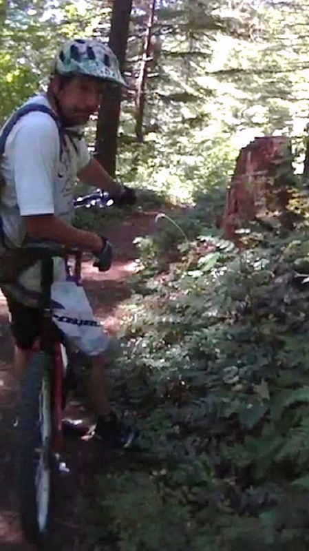
As we climbed up through the timber, Paul spotted a Lobster fungus growing next to the trail. Hypomyces lactifluorum, the lobster mushroom is a parasitic fungus that grows on other mushrooms.
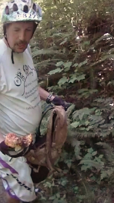
Paul quickly stepped off his bike and dropped it alongside the trail as he gently picked the fungus using both hands then pulled his pack off and stashed it inside. About to leave, he spotted a second lobster mushroom. Paul told me the only issue with the mushroom was that they could grow on and engulf a mushroom that was poisonous but that he was fairly sure it was not an issue around here.
I checked on line and found that indeed there has never been a reported fatality from ingesting the lobster mushroom, although there have been reports of people getting sick and of some just tasting bad.
We finally break across the ridge and start heading down the final descent back to the car. The line traverses the steepest slope we have crossed all day but the hillside is covered in large timber and the tread is very smooth.
Within seconds Paul has disappeared out of sight. A very fast run, I catch up to him just before the first switchback where he has stopped to lower his seat post.
Paul whips around the first switchback and again disappears as he rockets out of sight. I round the switchback and dropping back over the rear wheel let the bike fly. The next switchback has a large tree protruding out into the line just after the turn and the trail has sluffed off just below it, causing me to clamp on my brakes and push my bike a few feet past the tree.
All too soon we are at the bottom where neither of us can believe this last section was so short, because it sure didn't seem that way on the climb.
The ride took us 5 hours and 45 minutes, we had a total elevation differential of 2,548 feet. Starting at 913 feet and ending at 3461 feet, but I would bet that we climbed near 3,000 feet.